
Features
Applications
Swine
Remote control airboat measures lagoon sludge
March 14, 2008 by Kaushlendra Singh Dr. John Worley and Dr. Mark Risse
Lagoon management can be greatly aided by knowing how much sludge is in a lagoon at a given time.
Lagoon management can be greatly aided by knowing how much sludge is in a lagoon at a given time. As well, knowing the amount of build-up in a lagoon is necessary in order to monitor the effectiveness of sludge management products.
But actually measuring the sludge amount can be a laborious and dangerous job.
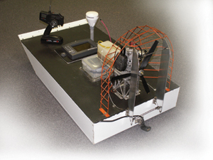 The GPS enabled 200kHz sonar equipped (LCX-15 Lowrance Electronics) remote controlled unmanned airboat, developed at the University of Georgia’s Department of Biological and Agricultural Engineering. The GPS enabled 200kHz sonar equipped (LCX-15 Lowrance Electronics) remote controlled unmanned airboat, developed at the University of Georgia’s Department of Biological and Agricultural Engineering. |
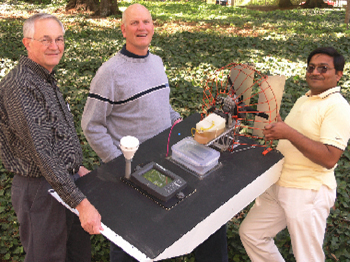 Dr. John Worley (left), Dr. Mark Risse (centre) and Kaushlendra Singh (right) pose with the University of Georgia’s Department of Biological and Agricultural Engineering air-powered remote controlled airboat, used to measure sludge depth in manure lagoons. Dr. John Worley (left), Dr. Mark Risse (centre) and Kaushlendra Singh (right) pose with the University of Georgia’s Department of Biological and Agricultural Engineering air-powered remote controlled airboat, used to measure sludge depth in manure lagoons. Advertisement
Photo by Erik Jarrett.
|
Traditionally, sludge has been measured manually using either a sludge gun or a sludge meter. Using these methods, the sludge depth is measured from the surface of the lagoon – using predefined grid points – by two people sitting in a boat. For safety reasons, an additional person or two needs to remain on the lagoon bank, just in case someone falls in and needs to be fished out.
Obviously, this traditional manual method of sludge survey is unhygienic, unsafe, time consuming, and inaccurate.
Recently, interest in the use of sonar waves for sludge measurements has increased among the scientific and business community. As a result, researchers with the University of Illinois developed a sludge boat to measure the sludge depth. This fiberglass hull sludge boat was equipped with a fish finder (depth finder) with GPS co-ordinate tracking. The boat was powered by two propellers and guided with a remote control.
Unfortunately, the system encountered a problem as the water-submerged propeller was prone to becoming clogged during the operation.
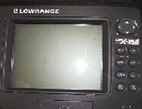 The airboat’s GPS receiver is coupled with a Lowrance Electronics fish finder or sonar unit, which also stores information about the speed, position, depth to top and bottom of sludge layer, and other details in a data file. The airboat’s GPS receiver is coupled with a Lowrance Electronics fish finder or sonar unit, which also stores information about the speed, position, depth to top and bottom of sludge layer, and other details in a data file. |
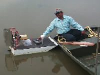 The distance from the surface of the water to the top and bottom of the sludge surface is measured using the airboat. Measurements are taken in a static condition at a single point, as observed in this photo, a dynamic condition along two lines of travel, and manually using a sludge meter method. The distance from the surface of the water to the top and bottom of the sludge surface is measured using the airboat. Measurements are taken in a static condition at a single point, as observed in this photo, a dynamic condition along two lines of travel, and manually using a sludge meter method. |
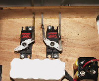 The airboat’s remote control unit has two actuators: one to control the boat’s direction by moving two air wings mounted behind the propeller, and the other to control the engine speed. The airboat’s remote control unit has two actuators: one to control the boat’s direction by moving two air wings mounted behind the propeller, and the other to control the engine speed. |
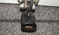 The sonar unit or fish finder uses a 200kHz transducer located at the bottom rear edge of the airboat. The sonar unit or fish finder uses a 200kHz transducer located at the bottom rear edge of the airboat. |
The University of Georgia’s Department of Biological and Agricultural Engineering decided to take over where Illinois left off, developing an air-powered remote controlled airboat, rather than a propeller driven one. The researchers tested its measurements for various settings of the control panel variables and validated the airboat measurements with reports by a private commercial firm using a similar, but more complicated system.
Description of the Georgia airboat
The remotely controlled unmanned airboat was designed and assembled by Pat Harrel, a UGA technician. The 44 inch long and 24 inch wide airboat is equipped with a fish finder sonar unit coupled with a global positioning system (GPS) receiver. The fish finder uses a 200kHz transducer located at the bottom rear edge of the airboat. The airboat is propelled by a gasoline engine driven propeller. Three Teflon bars are installed at the bottom of the airboat to reduce friction while moving over floating debris. The remote control unit has two actuators: one controlled the direction by moving two air wings mounted behind the propeller, and the other controls engine speed.
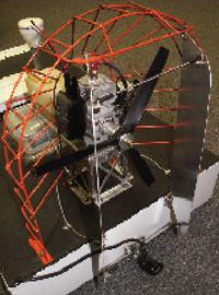 The airboat is propelled by a gas engine driven propeller. Two air wings mounted behind the propeller help to control the direction of the boat. They are activated through a remote control. This kind of propulsion unit results in less risk of The airboat is propelled by a gas engine driven propeller. Two air wings mounted behind the propeller help to control the direction of the boat. They are activated through a remote control. This kind of propulsion unit results in less risk of the boat sticking to sludge and inhibiting its movement. |
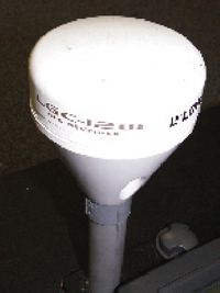 The 44 inch long and 24 inch wide airboat is equipped with a fish finder sonar unit coupled with a global positioning system (GPS) receiver. The 44 inch long and 24 inch wide airboat is equipped with a fish finder sonar unit coupled with a global positioning system (GPS) receiver. |
The researchers considered this boat very suitable for lagoon conditions because:
• The small size of the boat makes it easy to maneuver by remote control.
• The airboat propulsion unit has less
risk of sticking to sludge and inhibiting its movement.
• The unmanned boat does not cause any safety risk compared to traditional methods.
• One person can collect a large volume of data in 20 to 30 minutes compared to traditional methods requiring at least three men (two on boat and one on ground) collecting data much more slowly.
• The air-powered boat has no risk of clogging of propellers.
Testing and validation
On the airboat, the sonar unit collects the data in the form of a map of the bottom of the lagoon. To record and redisplay this map, the sonar unit also stores information about the speed, position, depth to top and bottom of sludge layer, and other details in a data file.
Based on discussion with Mark Rice, an animal waste management program extension specialist with North Carolina State University, and a review of literature available for the sonar unit, four variables – sensitivity, gray line, surface clarity, and noise rejection – were selected for the Georgia study.
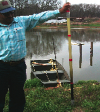 Researchers at the University of Georgia conducted experiments involving the airboat using a lagoon at the university’s swine centre. The airboat’s mapping abilities were tested against the traditional method of measuring sludge depth using a sludge meter. Researchers at the University of Georgia conducted experiments involving the airboat using a lagoon at the university’s swine centre. The airboat’s mapping abilities were tested against the traditional method of measuring sludge depth using a sludge meter. |
To study the effect of sonar unit variables on measurements of the top and bottom depth of sludge layer in the lagoon, two separate experiments were conducted in a lagoon at the University of Georgia Swine Center in Athens, Georgia. In a validation experiment, the same lagoon was mapped two days after a private commercial firm mapped the lagoon using their instrumentation, which consisted of a sonar unit mounted on a two-person boat. After dividing the lagoon in grids, the two-person boat carrying all the instrumentation was maneuvered over predefined grid points to measure the sludge depth.
After each experiment using the airboat, the data were downloaded to a computer from the airboat secure digital (SD) memory card. Using software provided by Lowrance Electronics, the manufacturer of the fish finder unit, the data file was opened and converted to a Microsoft Excel format. The numerical data in the columns included depth, water temperature, water speed, position-X, position-Y, surface depth, top of bottom, speed, track altitude and others. After each data column was an additional column indicating whether the data was ‘true’ or ‘false’. A ‘false’ reading indicated the data point was probably invalid due to lack of sufficient agreement of the data.
During the processing, all the false data of depth, and position was deleted. Statistical analysis was used to analyze the data obtained from the first two experiments.
Experiment results
Four major points were learned in the first experiments which compared the sonar boat data to a manual sludge measurement device and statistical analysis of experimental data.
1. The ‘Greyline’ setting did not affect
the results.
2. The ‘sensitivity’ setting should be set at 25 percent.
3. The boat needs to be moved at as constant a speed as possible to minimize the effect of speed on results.
4. A correction factor was needed to improve depth measurement because of the difference in the speed of sound in water vs. sludge. The researchers decided more work was needed to determine just what the correction factor needed to be.
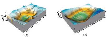
During validation analysis for the data collected by the airboat, the mapping data reported by the private firm was used as reference. The top surface of the sludge obtained from the airboat and that from the private firm are shown in Figure 1. Both surface maps for the top of the sludge looked similar except that the surface map resulting from the airboat data had more spikes on the surface. This non-smooth behavior might be due to the use of a less accurate GPS system with the airboat. The GPS system used by the private firm had accuracy within inches compared to several feet for the system used by the airboat GPS.
 Dr. John Worley (left), Dr. Mark Risse (centre) and Kaushlendra Singh (right) pose with the University of Georgia’s Department of Biological and Agricultural Engineering air-powered remote controlled airboat, used to measure sludge depth in manure lagoons. Dr. John Worley (left), Dr. Mark Risse (centre) and Kaushlendra Singh (right) pose with the University of Georgia’s Department of Biological and Agricultural Engineering air-powered remote controlled airboat, used to measure sludge depth in manure lagoons.
Photo by Erik Jarrett.
|
The maximum depth to the top of sludge reported by the private firm was 1.96 meters. For airboat data, after applying correction factors accounting for speed of sound in lagoon water, the maximum depth to the top of sludge was 1.90 meters and the maximum depth to the bottom of the sludge was 2.3 meters. No other data point, besides maximum depth to the top of sludge, could be validated as the private firm reported its data in an unknown coordinate system. Although depth to the top of sludge obtained from the two sources was close, further validation experiments are necessary to generalize this technology, in light of conclusions drawn from this study.
In summary
The University of Georgia’s Biological and Agricultural Engineering Cooperative Extension has developed a remotely controlled airboat capable of detecting the depth to the top and bottom layers of the sludge in a lagoon that could
be a cheap, hygienic and labor efficient alternative for a sludge survey. While
the airboat technology for sludge measurement is 15 to 20 times faster
and 70 percent less labor consuming, further research is needed to generalize this technology.
Kaushlendra Singh, Dr. John Worley and Dr. Mark Risse are with the University of Georgia’s Department of Biological and Agricultural Engineering in Athens, Georgia. They can be reached at ksingh@uga.edu, jworley@uga.edu, and mrisse@uga.edu respectively.